You can display companies, delivery or private addresses and also plan routes to these addresses on a map. For example, if you go to the General tab and switch from the company address to the delivery address, then the delivery address is also displayed on the Area map tab.
You need active Internet access to use the functions of this tab.
![]() In the toolbar menu click Map.
In the toolbar menu click Map.
Alternatively you can call the map via the context menu.
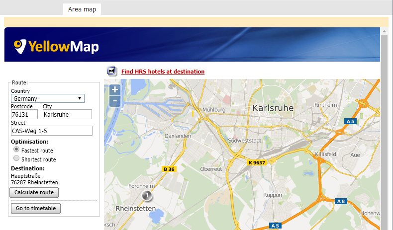
The addresses are displayed in a special YellowMap view. In the process, a new window is opened.
You can display a maximum of 40 addresses simultaneously.
The company, shipping or home address is displayed in a map.
![]() You can change the scale of the map by using the Zoom out or Zoom in functions.
You can change the scale of the map by using the Zoom out or Zoom in functions.
![]() You can use various buttons to display additional information on the map such as hotel addresses or other service providers.
You can use various buttons to display additional information on the map such as hotel addresses or other service providers.
Services include, for example, cash points, shopping locations and WLAN hotspots.
To the left of the map you will see the Calculate route area displayed.
For example, the Fastest route will take the least time.
The Shortest route is optimized according to kilometers or miles.
The address of the open data record is automatically entered as the destination.
The calculated route is then displayed on the map. Under the route, you will see all the route information and the directions.
If you have already entered a departure address in the Desktop Client settings, then this will be used automatically as your point of departure when planning routes.
![]() On Tools menu, click Settings.
On Tools menu, click Settings.
Departure and arrival destinations are entered automatically.